COVID-19 Coronavirus Notice

COVID-19 Coronavirus Notice

Updated 2 July 2020

If you are reading this message, please be aware of travel restrictions in place as part of measures to contain the spread of the COVID-19 "Coronavirus" and its symptoms. Japanese authorities are refusing entry to individuals from, or who have been to, a list of over 100 countries (More information). All other visitors must apply for a visa, and undergo a quarantine upon entering the country. Within the Japan, there are no longer any travel restrictions, and most public attractions have re-opened with precautions for sanitation and social distancing. In short, travel to Japan is not recommended at this time, until the situation normalises. I will not be editing my individual articles to reflect this, but again, please keep this in mind when reading them.
Showing posts with label transportation. Show all posts

Tuesday, December 17, 2019

Know Your Trains: Resort View Furusato

This article is based on a visit made on Saturday, 19 May 2018.

Previously on Sekai Ichi, I wrapped up a day trip to Takayama which, I would say, was one of the highlights of this trip.  After returning for our final night in Toyama, we were about to return to Tokyo.  But even though the Hokuriku Shinkansen provides a fast and direct link between the two cities, I felt like making a diversion along the way.  Our interim destination was the castle town of Matsumoto, and to get there, our route included a special train called the Resort View Furusato.

The Resort View Furusato (リゾートビューふるさと, Rizōto Byū Furusato) is one of JR East's lineup of "Joyful Trains".  These are specialised excursion trains which generally run on weekends and holiday periods, and have unique exterior and interior themes, often tying in with aspects of their particular regions.

The Resort View Furusato uses a 2-car HB-E300-series train, powered by a hybrid electric/diesel engine.  Inside, the Furusato may not appear as flashy as other Joyful Trains, but its essentials go above and beyond the call.  All seats have a generous pitch of 120 cm (47 inches), the most spacious regular seating in JR's entire fleet, and the windows are plenty wide, too.  At both ends of the train, there are small open areas where you can enjoy an even better view.  Traditional music performances are also held here, primarily on the western portion of the route which we skipped over.

Mid-way between Nagano and Matsumoto, the train makes an extended stop at Obasute Station.  Two things stand out about this station: first, there is a switchback here, where the train must change directions to climb up or down, not unlike certain points of the Hakone Tozan Railway.  And second, the platform has a commanding view of the Zenkoji Plain below, towards Nagano.

Attendants are also on hand throughout the whole journey.  You can buy certain snacks and gifts from them -- such as products made with apples, an agricultural specialty of Nagano Prefecture -- and they are happy to assist with taking your picture, such as I did at the above-mentioned stop.


We disembarked at Matsumoto, but the Resort View Furusato continues up the Oito line, which skirts up the eastern edge of the Japan Alps.  If you want to go to the Tateyama-Kurobe Alpine Route, you can take this train to Shinano-Omachi station, and transfer to a bus from there.  Kurobe Dam (pictured), one of the route's highlights, can be reached in only an hour from Shinano-Omachi.  Beware that if you do so, make sure you have enough time to catch the last connection at each stop, since crowds are liable to build up by the time you get there.  For more information, please read my introduction article on the Alpine Route here.

663highland [CC BY-SA 3.0], via Wikimedia Commons
On its outbound journey, the train also makes an extended half-hour stop at Hotaka.  This gives you enough time to visit Hotaka Shrine which, despite being situated right next to the station, is nestled within a pleasant wooded grove.  In that regard, it reminds me of Meiji Shrine in Tokyo.  Even Hotaka Station is modelled after the shrine's bare-wooden architecture!

Ski Mania [Public domain], via Wikimedia Commons
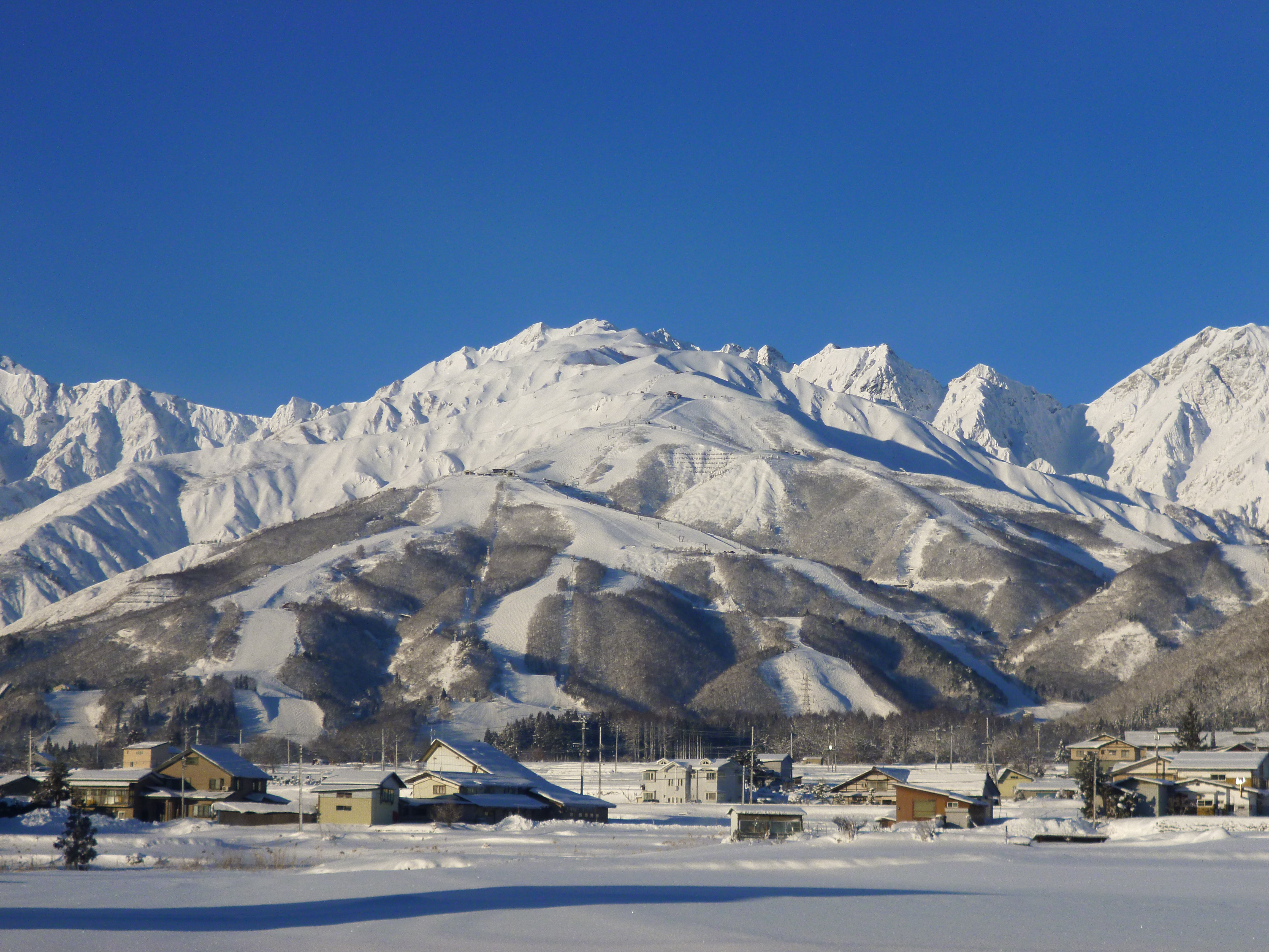
The far end of the line, from Hakuba to Minami-Otari, is home to a dense cluster of ski resorts, accessible by buses from either of the two stations as well as from Nagano.  The largest ski zone is Happo'one (pictured), which hosted Downhill and Super G skiing events during the 1998 Winter Olympics.


The Resort View Furusato runs on most Saturdays and Sundays, and some additional periods, including almost the entire month of August.  For up-to-date operating schedules, please visit the links at the bottom of this article.

StationResort View Furusato
for Minami-Otari
StationResort View Furusato
for Nagano
Nagano9:04 AMMinami-Otari3:18 PM
Shinonoi9:13 AMHakuba3:33 PM (Arr.)
3:39 PM (Dep.)
Obasute9:28 AM (Arr.)
9:45 AM (Dep.)
Shinano-Omachi4:20 PM (Arr.)
4:21 PM (Dep.)
Akashina10:11 AM (Arr.)
10:12 AM (Dep.)
Shinano-Matsukawa4:30 PM (Arr.)
4:31 PM (Dep.)
Matsumoto10:27 AM (Arr.)
10:41 AM (Dep.)
Hotaka4:42 PM (Arr.)
4:45 PM (Dep.)
Hotaka10:59 AM (Arr.)
11:31 AM (Dep.)
Matsumoto5:14 PM (Arr.)
5:23 PM (Dep.)
Shinano-Matsukawa11:41 AM (Arr.)
11:42 AM (Dep.)
Akashina5:40 PM
Shinano-Omachi11:52 AM (Arr.)
12:02 PM (Dep.)
Obasute6:06 PM (Arr.)
6:07 PM (Dep.)
Hakuba12:34 PM (Arr.)
12:42 PM (Dep.)
Shinonoi6:19 PM
Minami-Otari1:00 PMNagano6:29 PM

Tips
  • All seats on the Resort View Furusato are reserved.  The supplement fee is a flat ¥530 on top of regular fare.
  • The Resort View Furusato is classified as a rapid train, so you can ride it for free with the Japan Rail Pass, JR East Nagano-Niigata Pass, and even the Seishun 18 Ticket.
  • For the best views during the Nagano-Matsumoto section, including the Obasute overlook, sit on the right side of the train (for outbound services).  For the best views of the Japan alps beyond Matsumoto, sit on the left side (outbound).

More information: (English) (Japanese)

Tuesday, May 14, 2019

Alpine Route Part 3: Murodo to Kurobe Dam

This article is based on a visit made on Wednesday, 16 May 2018.

Edit 11 October 2019: Updated prices to reflect the increase in Japan's national sales tax.

Previously on Sekai Ichi, my grandmother and I reached the peak of the Tateyama Kurobe Alpine Route, the Murodo Highlands.  But this was only the half-way point of our adventure.

To pick up from where we left off, we took the Tateyama Trolleybus from a station directly adjacent to the Tateyama Hotel.  A trolleybus is a bus that is powered by overhead electrical lines, like a trolley or a bumper car.  This particular trolleybus drives through a tunnel narrow enough for only one bus at a time.  However, like the earlier cable cars, there is a section in the middle which allows buses heading in opposite directions to pass each other.

At the other end, we find ourselves at Daikanbo, the upper station of the Tateyama Ropeway.  With a distance of 1.7km (1.1 mi.), and a vertical difference of 488m (1,601 ft.), this is the world's longest aerial lift without any mid-span supporting towers.  Due to the limited capacity of the cars, this is one of the Alpine Route's more infamous bottlenecks.

If you do find yourself with extra time to spare, you can walk upstairs to the observation deck, which looks out upon the Kurobe Dam and the surrounding valley.  Or, just do what I did, and take pictures from the front of the gondola.

Upon alighting at the lower station, Kurobedaira, we then have one more ride to go before reaching the Kurobe Dam, and it is the Kurobe Cable Car.  We already went through one of these at the other end, so you know the deal by now.

Finally, we reach the Kurobe Dam.  It was constructed between 1956 and 1963 to meet the growing electricity needs of western Japan in the post-World War II period.  At 186 metres (610 feet) tall and 492m (1,614 ft.) wide, it is the largest hydroelectric dam in Japan.

As part of the Alpine Route, visitors will have to cross the dam on foot.  This simple walk should only take ten to fifteen minutes.  Along the way, you will get to see views such as this one, looking downstream to the north.

The other side, to the south, consists of the dam's reservoir, Lake Kurobe.  I didn't find the views from this angle quite as appealing, due to all the tree trunks and other detritus that had washed up to the edge of the dam.  But, I suppose that algae-fueled emerald-green colour is brilliant in its own way.

Wherever you take pictures from, be very careful to keep a tight grip on your camera, or whatever you're taking pictures with!  I would hate for you to drop it from so far up!

On the east side of the dam stands a restaurant and gift shop, as well as a small museum about the construction of the dam, which is free to visit but only has descriptions in Japanese.   At the end of the hall is a mockup of the tunnel that was dug out to reach the area from across the neighbouring mountains.  Reportedly, a total of ten million people were involved in the project which, if true, would be over 10% of the population of the entire country at the time (e.g. over 94 million people in 1960).  171 of those people died while working on the dam.  They are honoured by a memorial statue, located on the east side of the dam, a bit along the lake.

If you want a better view of the dam, there are two additional places you can choose to head to.  The first is an observation deck situated at the top of a 220-stair, 15-minute ascent.  It's a bit of a hike for some people.

If that sounds too hard, or time-consuming, you can also go down a shorter staircase to a newer observation deck, which brings you much closer to the dam.  This looks like a spectacular place to see the water discharges which take place from June through October.  As of this article, the discharges will next take place from 26 June through 15 October 2019.  Those deluges, and the rainbows that often form amidst the sprays, would certainly make the sight of this dam less drab, but when you're here in person, the sheer scale of this thing is always impressive in its own right.

Another activity I was unable to take advantage of at the time is the "Garve" pleasure cruise, which makes 30-minute trips around the lake from June to early November.  Tickets for this ride cost ¥1,080.

The mascot of Kurobe Dam is a black cat in a hard hat, called Kuronyon.  "Kuro" means "black", and "nyon" is a Japanese word for the sound a cat makes.  Naturally, he is featured on plenty of merchandise sold here...


...as is "Dam Curry", a specialty of the local restaurant.  Here, the rice forms an arched dam shape to hold back the sauce, which is blended with spinach to create a green tint.  If the thought of this tickles your taste buds, the gift shop sells packs of this curry mix for you to make at home.  If not... well, you can always buy this dish in plastic keychain form.

Once we're done here, one last official leg of the Alpine Route remains, and that is the Kanden Trolleybus.  "Kanden" here is short for Kansai Electric Power Company (KEPCO), the company which owns and operates the Kurobe Dam.  The tunnel used by the trolleybus today, which crosses the boundary between Toyama and Nagano Prefectures, was originally dug out to transport people and materials for building the Kurobe Dam.  As with the other trolleybus, the tunnel is wide enough only for single buses, apart from a passing section in the middle.

And with that, we are pretty much finished!  All that's left to do, besides this sign-off selfie I took at the bus station, was to find our way back to our hotel.  For some, this may involve taking a local bus to one of the hot-spring resorts in the town of Omachi.  For us, that involved taking an express bus to Nagano, and the Hokuriku Shinkansen back to Toyama.  Finally, after such a hectic but interesting day, we had earned our rest.  We would follow that up, with a considerably more relaxed start, by taking an excursion to an all-new city, which I invite you to join me on, next time on Sekai Ichi!


Kurobe Dam

Hours: The dam itself is open 24 hours, but transportation to/from the dam is not.  For most seasons, the first Kanden trolleybus leaves Ogizawa for Kurobe Dam station at 7:30 AM, and the last returning bus departs for Ogizawa at 5:35 PM.  Closed, along with the rest of the Alpine Route, from mid-November to mid-April.  The "Garve" pleasure cruise operates from early June to mid-November, and runs daily from 9:00 AM to 3:00 PM.  Schedule: (English)

Cost: Free.  The "Garve" pleasure cruise costs ¥1,080 per ride.

Address: Ashikura-ji, Nakaniikawa-ku, Toyama-ken 〒930-1406

Access: Kurobe Dam is part of the Tateyama-Kurobe Alpine Route.  From Shinano-Omachi station, take a bus to Ogizawa Station (40 minutes), followed by the Kanden Trolleybus to Kurobe Dam (16 minutes).  Round-trip fare for this section costs ¥5,110.

Website: (Japanese)

Tuesday, May 7, 2019

Alpine Route Part 1: Toyama to Murodo

Before we begin, for those of you who are unaware, Akihito, the Emperor of Japan since 1989, has officially abdicated his position.  Starting from 1 May 2019, the position has been picked up by his eldest son, the new Emperor Naruhito.  Thus, this article marks this blog's first post of the new Reiwa era of Japan.  I express my congratulations to the new Emperor, and my hopes that he will help keep Japan awesome.  And now for our regularly-scheduled article.


This article is based on a visit made on Wednesday, 16 May 2018.

Edit 11 October 2019: Updated prices to reflect the increase in Japan's national sales tax.

Previously on Sekai Ichi, I had introduced the Tateyama-Kurobe Alpine Route, so it only makes sense that follow that up with a more detailed report of my own.  Indeed, I had originally scheduled a day-trip along the route for Thursday, the 17th of May, following a day-trip to Kanazawa the day before, but looking ahead at the weather forecasts, I decided on-the-fly to swap the two days, in order to have better weather for traversing the Alpine Route.  That turned out to be a good call, but let's not get ahead of ourselves.

We left from Dentetsu-Toyama Station, the terminus of the Toyama Chiho Railway, at about 7 o'clock in the morning.  We could have waited for the limited-express train (right) departing later that hour, but since I was worried about running out of time later on, we instead chose the regular train (left).  Unfortunately, there was no seating room left on our train, meaning we had to stand against the walls for the entire hour-plus ride.

At least the views were lovely.  As we rode deeper into the mountains, the trees got greener and the streams got bluer.

At our next stop, Tateyama Station, we lined up for the Tateyama Cable Car.  It departs from either end every twenty minutes, giving the queues a chance to build up.  TV monitors, such as those above the gate, show a loop of current weather conditions for stopping points along the route.

If one is not in a hurry to continue up the route, they could stay in town, to take in nearby museums such as the Tateyama Caldera Sabo Museum, exhibiting Mt. Tate from a geological standpoint, or further afield, the Tateyama Museum, showcasing history and art related to the mountain.  Or, they could take a bus ride (20 minutes, ¥500) to Shomyo Falls, the tallest regular waterfall in Japan.  During times of snowmelt, it is accompanied by Hannoki Falls, Japan's tallest seasonal waterfall.

The store was decorated with banners designed by a local artist, each representing different aspects of the Toyama region.  Their designs include the sea, the mountains, the "raicho" birds, the farm houses of Shirakawa-go, the glassware of Toyama city, and the Hokuriku Shinkansen.  Try to guess which is which!  Presumably, they were used on certain products at the store as well, but I do not specifically recall.  I quite like them, though.

A poster for the Alpine Route featured its mascots, the Tateyama Kurobe Alpine Girls.  From left to right, they are named Yuki Otani (大谷ゆき), Kaede Midahara (弥陀原かえで), and Mikuri Ikeno (池乃みくり).  They represent the appearance of the route in Spring, Autumn, and Summer respectively, and are named after specific points along the route (the snow canyon, the Midagahara marsh, and the Mikuri pond).  They're awfully cute; in fact, I'm picking up a distinct Powerpuff Girls vibe from them.

The Tateyama Cable Car is, like the one we rode in Hakone, a funicular designed for climbing up and down hills.  Maybe it's just me, but this one seems steeper than the Hakone Cable Car.

One thing's for certain, this one was more crowded.

From the cable car's top station, Bijodaira, travellers board a bus for a 50-minute ride up the mountain.  Or, they can choose to stay at Bijodaira and take one of several hiking trails through the primeval cedar forest.  The biggest of these trees measure 20-30 metres (65-98 feet) tall, 6-10m (20-33 ft.) in circumference, and/or are over 1,000 years old.  There is also a folk legend attached to one particular tree.  1,300 years ago, when women were forbidden from climbing Mount Tate, a princess prayed to one of the cedar trees that she would be reunited with her fiance, who was the first man to have climbed the mountain.  Eventually, they were re-united and married.  This story contributed to the name of the area, Bijodaira (美女平, lit. "beautiful-woman plains").

As the bus ascended the mountains, the tree coverage gradually gave way to snow that had accumulated over the winter and still had yet to thaw.  Many other mountains can be seen along the way, including Mount Tate (立山, Tate-yama, not pictured), the 3015-metre (9,892-foot) peak which gives the Tateyama-Kurobe Alpine Route part of its name.

About halfway through the bus ride, somewhere before this picture was taken, is Midagahara, a marshland situated about 1,900 metres (6,233 feet) above sea level.  It has a couple of looping boardwalk trails from which hikers can view alpine flowers from June through September, and autumn foliage, largely in the form of marsh grasses and bushes that turn golden-orange, from late September through October.  However, these paths are closed during periods of snow, which included the time of my visit in mid-May.

As we approached our destination, the Murodo highlands, the walls of snow on either side of the road towered over our bus.  Here's a preview of what to expect.

But the snow canyon will have to wait.  Until then, I shall leave you with a sign-off selfie, taken with me and my grandmother while we were waiting at Tateyama Station.  I will, of course, return to coverage of Murodo and its snow canyon, next time on Sekai Ichi!


Tateyama Caldera Sabo Museum

Hours: Open from 9:30 AM to 5:00 PM.  Closed Mondays.

Cost: ¥400.

Address: 68 Ashikuraji Bunazaka, Tateyama-machi, Toyama-ken 〒930-1405

Access: 1 minute on foot from Tateyama Station.  Head straight from the exit to Tateyama Station.  At the end of the sidewalk, the museum will be on your left.

Website: (English) (Japanese)

Tateyama Museum

Hours: Open from 9:30 AM to 5:00 PM.  Admission ends 30 minutes before closing time.  Closed Mondays.

Cost: ¥300 for Tenji-kan, ¥100 for Yobo-kan, ¥400 for Mandala Park, and ¥650 for all three.

Address: 93-1 Ashikuraji, Tateyama-machi, Toyama-ken 〒930-1406

Access: Take the Chitetsu Tateyama line to Chigaki Station (from Dentetsu-Toyama: 55 minutes, ¥1,040; from Tateyama: 15 minutes, ¥420).  As long as you do not backtrack, this is free with an Alpine Route ticket.  From Chigaki Station, take an Ashikura-ji Line bus to Oyama Jinja-mae (雄山神社前, 5 minutes, ¥200 (schedule)).  Note that this bus is unavailable on Sundays.  The museum can also be reached in a 30 minute walk from Chigaki Station.  Turn right from the station and continue up Route 6 for 2km.  The Tenji-kan will be on your left, and the Yobo-kan and Mandala Park are down a side alley, 3 minutes down on your right.

Website: (English pamphlet) (Japanese)

Tuesday, April 9, 2019

Introduction to: Tateyama-Kurobe Alpine Route

This article is based on a visit made on Wednesday, 16 May 2018.

Edit 11 October 2019: Updated prices to reflect the increase in Japan's national sales tax.
Edit 14 May 2020: Updated to add information on luggage forwarding services

The Tateyama-Kurobe Alpine Route (立山黒部アルペンルート, Tateyama Kurobe Arupen Rūto) is a sequence of transportation sections traversing the northern Japan Alps.  The concept of the Alpine Route came about after the construction of the Kurobe Dam, the largest hydroelectric dam in Japan.  Roads and tunnels built to aid in the dam's construction were re-tooled for tourism, creating the Alpine Route in 1971.  Visitors traversing the route will ride various trains, buses, and cable cars, all the while witnessing beautiful natural vistas, with multiple opportunities to stop and take hikes.  The entire route is opened only from mid-April to the end of November.

The route may be crossed in either direction, or you may also go to a certain point and turn back mid-way.  For the purposes of this blog, I will describe the route going from west to east, since that is how I took it.  Also, English reading order.

Transportation Sections

A) Toyama Chiho Railway: Not officially part of the Route, but the best method to access Tateyama Station, its westernmost point.
Time: 60 minutes
Departures: 1 per hour

B) Tateyama Cable Car: An inclined cable car at the western base of Mount Tateyama.
Time: 7 minutes
Departures: Every 20 minutes

663highland / CC BY-SA
C) Highland Bus: A regular bus service climbing most of the way up Tateyama, with occasional stops at the Midagahara plateau.
Time: 50 minutes
Departures: Every 40 minutes

D) Tateyama Trolleybus: A trolleybus, powered by overhead electricity, driven along a tunnel cut through the top of Tateyama.
Time: 10 minutes
Departures: Every 30 minutes

E) Tateyama Ropeway: The longest single-span (1.6km / 1 mi.) hanging cable-car in Japan.
Time: 7 minutes
Departures: Every 20 minutes

F) Kurobe Cable Car: An inclined cable car at the eastern base of Tateyama.
Time: 5 minutes
Departures: Every 20 minutes

G) Kanden Trolleybus: A trolleybus cutting through a tunnel within Mount Akasawa-dake, linking Kurobe Dam to the outside world.
Time: 16 minutes
Departures: Every 30 minutes

H) Alpico Kotsu Bus: A local transportation company offering regular buses to Omachi, and highway buses to Nagano.  Not officially part of the Route, but the best method to access Ogizawa, its easternmost point.
Time: 40 minutes (to Omachi), 105 minutes (to Nagano)
Departures: 1-3 per hour (to Omachi), 1 per hour (to Nagano)

Stops and Attractions

XF10 / CC BY-SA
1) Tateyama: The western end of the Alpine Route, boasting a few small museums.

Bijodaira04bs3200
663highland / CC BY-SA
2) Bijodaira: A virgin beech/cedar forest, with giant trees and folk legends.

Shomyo Falls (left) and Hannoki Falls (right).
I, Kahusi / CC BY-SA
3) Shomyo Falls: The tallest regular waterfall (350m / 1,148 ft.) in Japan.  In Spring, melting snow feeds the even taller (497m / 1,640 ft.) Hannoki Falls.

Alpsdake / CC BY-SA
4) Midagahara: One of the largest and highest alpine wetlands in Japan, with boardwalk-lined hiking trails.

5) Murodo: The highest point (2,450m / 8,038 ft.) of the Alpine Route, with many more hiking trails.  From April to June, a canyon is carved out of snow accumulated over the winter.

6) Daikanbo: The upper station of the Tateyama Ropeway.  Offers sweeping views looking down upon Kurobe Dam and the surrounding valley.

くろふね [CC BY 3.0], via Wikimedia Commons
7) Kurobedaira: The lower station of the Tateyama Ropeway.  Offers additional views looking down closer to Kurobe Dam, or up at Tateyama.

8) Kurobe Dam: The tallest dam in Japan, measuring 186 metres (610 ft) tall.  From June to October, it releases regular discharges of water, and cruise boats ply the reservoir above.

Shinano-Omachi Station.
663highland / CC BY-SA
9) Omachi: The eastern end of the Alpine Route, boasting numerous hot-spring resorts.

Costs

Tickets for the Alpine Route may be purchased from stations at either end.  Costs vary depending on the distance travelled, but one-way tickets for the whole length cost ¥11,050 per person.  For any given ticket, stopovers along the way are allowed, but backtracking is not.  A few money-saving value tickets are available, some of them exclusively for foreign visitors.
  • The Tateyama-Kurobe Option Ticket, ¥9,800, covers a one-way journey across the Alpine Route, including the express bus to/from Nagano.  It is good for five consecutive days, but must be purchased no later than the day before you intend to start using it.  It must be purchased inside Japan, and is available at Narita, Haneda, and Kansai airports, and major train stations in the JR East and JR West areas.  Train transportation to and from the Alpine Route itself is not included.  More information: (English)
  • The Alpine-Takayama-Matsumoto Area Pass, ¥17,830 (¥18,850 when purchased inside Japan), covers JR trains between Nagoya and Toyama (via Takayama), between Nagoya and Shinano-Omachi (via Matsumoto), and transportation along the Alpine Route itself.  It may be pre-purchased online for a discount, and exchanged or purchased directly at Chubu Centrair airport, and at major train stations in the JR Central area.  More information: (English)
  • JR Central also sells the "Tateyama Kurobe Alpine Kippu", a family of tickets which combine Alpine Route transportation with round-trip train fare from Nagoya, Kyoto, Osaka, or other cities, for eight consecutive days.  Unlike the above passes, these are sold to Japanese citizens as well as foreigners, although they may not be as good a value as the alternatives.  Costs for these tickets vary depending on the starting city, and which of several routes are taken.  More information: (Japanese)
  • Starting City Route Cost
    Nagoya "Hida Course" (via Takayama) ¥18,950
    "Shirasagi Course" (via Kanazawa) ¥22,250
    Kyoto "Hokuriku Round-trip" (via Itoigawa/Kanazawa) ¥23,660
    "Hokuriku/Chuo Course" (via Matsumoto/Nagoya) ¥26,220
    Osaka "Hokuriku Round-trip" (via Itoigawa/Kanazawa) ¥24,710
    "Hokuriku/Chuo Course" (via Matsumoto/Nagoya) ¥27,370
Access

With an early start, it is possible to traverse all or part of the Alpine Route as a day trip from Tokyo.  From Tokyo, take the Hokuriku Shinkansen to Nagano (80-100 minutes, ¥8,340 reserved, JR Pass OK), and an express bus to Ogizawa (105 minutes, ¥2,800).  These buses depart from the East Exit of Nagano Station, on the same side as the Shinkansen tracks.  On the other side, take the Hokuriku Shinkansen from Toyama back to Tokyo (130-160 minutes, ¥12,960 reserved, JR Pass OK).  This trip can also be done in the opposite direction.

A longer, but more scenic, approach from Tokyo is to take the Azusa or Super Azusa limited express from Shinjuku to Matsumoto (160 minutes), followed by the JR Oito line to Shinano-Omachi (55 minutes, total ¥7,390 reserved, JR Pass OK).  The bus between Shinano-Omachi and Ogizawa takes 40 minutes, and costs ¥1,390.  Unlike the express buses from Nagano, the Option Ticket is not valid on these buses.

Coming in from western cities takes even more time, and while it still may be possible to go and come back in a single day, it is less advisable.  From Nagoya, take the Shinano limited express either to Nagano, or via Matsumoto to Shinano-Omachi (3 hours, total ¥7,460 / 6,800 reserved, JR Pass OK).  On the way back, take the Hokuriku Shinkansen to Kanazawa (25 minutes), followed by the Shirasagi limited express to Nagoya (3 hours, total ¥9,210, JR Pass OK).  Alternately, there are a few direct Hida limited express trains that go straight to Nagoya, via Takayama (4 hours, ¥7,790 reserved, JR Pass OK).

From Kyoto, take the Tokaido Shinkansen to Nagoya (35-50 minutes), followed by the Shinano either to Nagano, or via Matsumoto to Shinano-Omachi (3 hours, total ¥11,130 / 10,800, JR Pass OK).  On the way back, take the Hokuriku Shinkansen to Kanazawa (25 minutes), followed by the Thunderbird limited express to Kyoto (130 minutes, total ¥9,040 reserved, JR Pass OK).  From Osaka (Shin-Osaka Station), add an extra 15 minutes and about ¥550 both ways.

Tips
  • While day trips along the route are possible from the above-mentioned cities, you will be very pressed for time if you attempt it.  A better idea would be to spend the night at one of the cities at either end of the route.  Some good choices are Nagano, Matsumoto, and Omachi on the east side, and Toyama or Kanazawa on the west.  There are even a couple of hotels along the route itself, including the Hotel Tateyama at Murodo, which just so happens to be the highest hotel in Japan by elevation.
  • Wait times can be a serious issue at certain points along the Alpine Route.  On weekends, and during the snow wall season from April to May, prepare for queues at transfer points to last an hour or more.  Bottlenecks to be particularly aware of include the trolleybuses and the Tateyama Ropeway, due to limited capacity and/or departure frequency.  The Apline Route's official website includes a calendar of projected wait times per day: (English) (Japanese)
  • Luggage forwarding services are available for part or all of the Alpine Route, ranging in cost from ¥1500 to ¥2500 per piece.  In order to have it arrive at the other end on the same day, make sure you drop it off early enough.  The same-day delivery times vary depending on where you're sending your luggage from.  More information: (English) (Japanese)
  • Private cars are not allowed on any section of the Alpine Route between Tateyama and Ogizawa.  There are free and/or paid parking lots at both ends.  For those who wish to have their car delivered from one end to the other, instead of backtracking, this will cost ¥26,000 for most cars.  More information: (English) (Japanese)
Trivia
  • Kurobe Dam was constructed between 1956 and 1963, to meet the growing electricity needs of the post-war Kansai region.  Of the 10 million people who were employed over the course of this period [citation needed], 171 workers lost their lives.  A monument made in their honour may be found along the reservoir.
  • Since "Omachi", the name of the town at the east end of the Alpine Route, is a common place name in Japanese, it is often referred to as Shinano-Omachi.  Shinano Province (信濃国, Shinano no Kuni) is the former name of Nagano Prefecture before 1871.