COVID-19 Coronavirus Notice

COVID-19 Coronavirus Notice

Updated 2 July 2020

If you are reading this message, please be aware of travel restrictions in place as part of measures to contain the spread of the COVID-19 "Coronavirus" and its symptoms. Japanese authorities are refusing entry to individuals from, or who have been to, a list of over 100 countries (More information). All other visitors must apply for a visa, and undergo a quarantine upon entering the country. Within the Japan, there are no longer any travel restrictions, and most public attractions have re-opened with precautions for sanitation and social distancing. In short, travel to Japan is not recommended at this time, until the situation normalises. I will not be editing my individual articles to reflect this, but again, please keep this in mind when reading them.
Showing posts with label nature. Show all posts

Monday, May 13, 2019

Alpine Route Part 2: Murodo

This article is based on a visit made on Wednesday, 16 May 2018.

Previously on Sekai Ichi, my grandmother and I embarked on a day-trip across the Tateyama Kurobe Alpine Route.  In the first half, we climbed uphill via the Toyama Chiho Railway, the Tateyama Cable Car, and a bus.  All of that led us to Murodo (室堂), a plateau sitting at 2,450 metres (8,038 feet) above sea level, and the highest point of the Alpine Route.

The buses drop you off at the Hotel Tateyama, the highest hotel in Japan by elevation.  For those not staying overnight, it also has a restaurant, gift shop, and is directly connected to the next section of the Alpine Route, the Tateyama Trolleybus.  But let's not get ahead of ourselves.

The Alpine Route's website claims that Tateyama receives some of the world's heaviest snowfalls.  Citation needed on that statement, but I can certainly attest that there was lots and lots of snow to go around.  In fact, the snowfall accumulated here during any given winter doesn't fully melt until the middle of summer, if at all!  To view this panorama in full size, click here.

In order to clear the roads for the Alpine Route, all that snow has to be dug out, forming a massive "snow corridor" (雪の大谷, yuki no ōtani).  A 500m (1,640 ft.) section of this canyon, starting from the parking lot of Hotel Tateyama, is partially roped off for pedestrians to walk down and get a closer look.  This snow canyon can measure up to 20 metres (66 feet) tall.

On this occasion, the snow wall was measured to be 14 metres (46 feet) tall.  Given that this was a month into the open season, that's not too shabby!  They also logged the temperature at 7° Celsius (45° Fahrenheit), which was considerably cooler than the lower portions of the Alpine Route, so when traversing the route, I would definitely suggest wearing layers.

So many people had drawn messages and little pictures in the snow...

...that I felt like doing one myself.

Along the way, we got our picture taken with stuffed models of rock ptarmigans (雷鳥, raichō, lit. 'thunder bird').  The ptarmigan breeds in arctic and sub-arctic regions, including Alaska, Canada, Greenland, Iceland, Scotland, Norway, Russia, and the mountains of Central Japan, where we are now.  It has even been designated the official bird of Toyama, Gifu, and Nagano prefectures, all of which border the Japan Alps.  If you recall my last few articles, this so-called "thunder bird" inspired the name of the train we took to get from Kyoto to Toyama.  More information on ptarmigans and other wildlife of the area can be learned at the Tateyama Nature Conservation Centre, a free museum next-door to the hotel.

Back in the lodge, we dug into a lunch of pork cutlets, then bought some postcards and mailed them right from the shop.  I also bought these papercraft models of buses and cable cars from the Alpine Route, which I had to fold and stick together myself.  There were plenty of tricky bits, but I think I got the hang of it by the end!


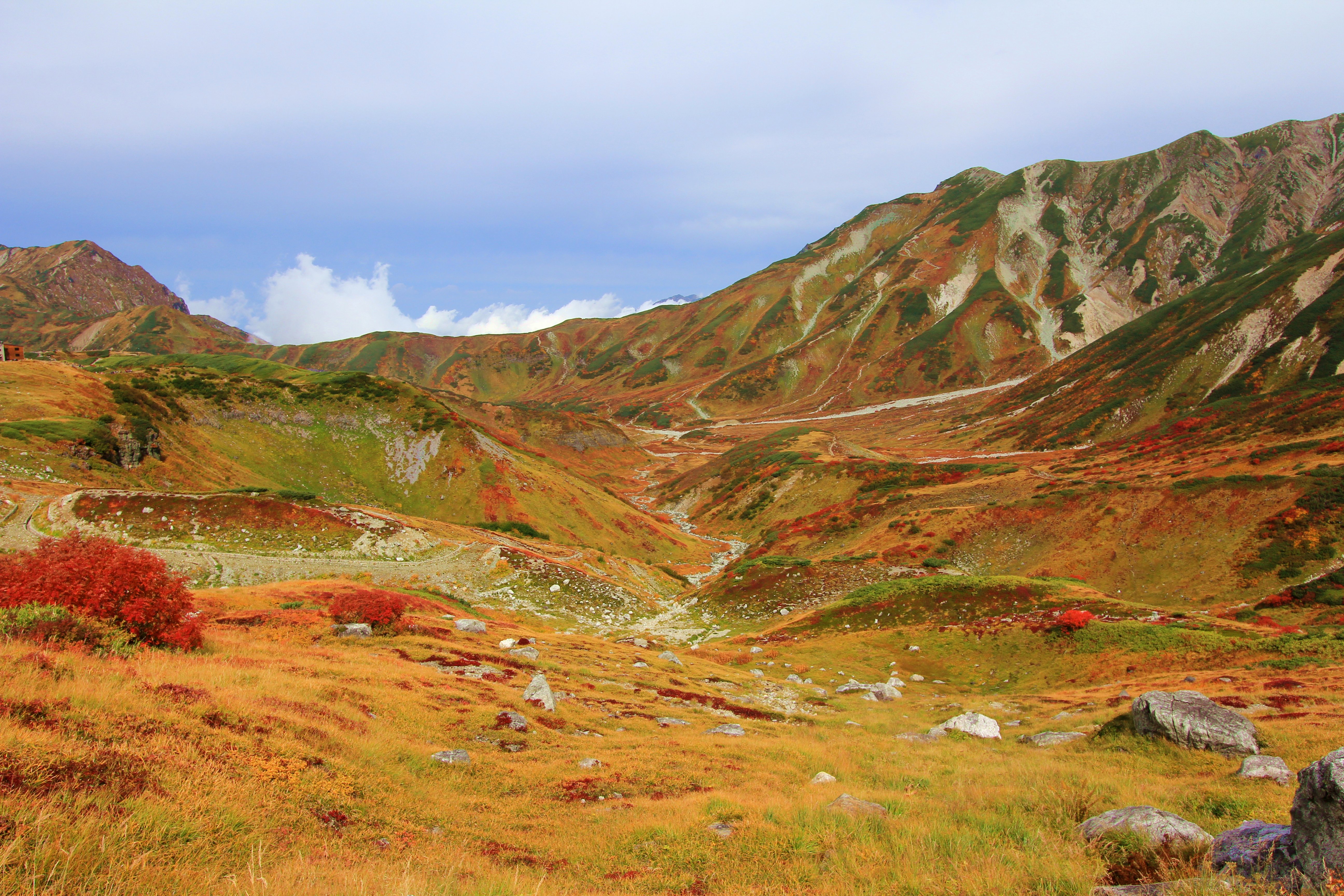
The Murodo Highlands in autumn, taken 6 October 2012.
くろふね [CC BY 3.0], via Wikimedia Commons
As marvellous as the snow canyon is, it overshadows, and in some cases precludes access to, many other natural wonders around the area.  This includes the very same landscape in different seasons.  The scenery that is blanketed by white snow in winter and spring turns green in the summer, and gold with red bushes in the autumn.

Mikurigaike, taken on 1 August 2015.
くろふね [CC BY 3.0], via Wikimedia Commons
There are numerous volcanically-formed ponds around the area, the biggest being Mikurigaike (ミクリガ池).  The reflections from this clear blue lake are truly brilliant.  Walking here from the Tateyama Hotel takes only 15 minutes one-way.

Mikurigaike Onsen, taken on 15 July 2018.
Saigen Jiro [CC0], via Wikimedia Commons
Just beyond the pond is Mikurigaike Onsen, Japan's highest public hot-spring facility by altitude.  The indoor baths here offer sweeping views of the Murodo Plateau.  This place also has dormitories and rooms to stay the night in.  Hotel Tateyama also has hot-spring baths, but they are for staying guests only.

Murodo's jigokudani, taken on 13 November 2015.
Alpsdake [CC BY-SA 4.0], via Wikimedia Commons
The Murodo plateau also has its own "hell valley" (地獄谷, jigokudani), where volcanic gases are vented from the barren ground.  The source of these is a small volcano, somewhere along the edge of the plateau, whose last eruption was a small one in 1839.  Walking trails pass through here too, but they are frequently closed off due to volcanic activity.

Oyama, and the shrine that stands atop it.
Alpsdake [CC BY-SA 4.0], via Wikimedia Commons
From Murodo Station, it is even possible to hike up to the top of Mount Tate (立山, lit. 'standing mountain').  Tate-yama consists of three adjacent peaks, of which the 3,003m (9,852 ft) Oyama (雄山, lit. 'masculine mountain') is the most popular for climbers.  From the Tateyama Hotel, the trail to Oyama is 2.5km (1.5 mi) long and takes about 2 hours to ascend.  It is more strenuous than other paths in the area, but does not require special equipment beyond sturdy hiking shoes and warm clothing.

As for me... let's not and say we did.  I can, at least, prove I was in the general area with this sign-off selfie of me mailing our postcards.  With Murodo, we have perhaps reached the peak of the Tateyama Kurobe Alpine Route, in more ways than one.  But there remains the entire second half of the route to be seen, including the nation's tallest dam.  Check it out with me, next time on Sekai Ichi!


Hotel Tateyama

Cost: As of May 2019, the average rate per person/night is ¥22,000 to ¥28,000 for a twin room.  Rates include dinner and breakfast.

Address: Ashikura-ji, Tateyama-chō, Nakaniikawa-gun, Toyama-ken 〒930-1414

Access: The hotel is adjacent to Murodo Station.

Website(English) (Japanese)

Tateyama Nature Conservation Centre

Hours: Open from 8:30 AM to 5:00 PM.  Opens at 8:00 AM from 16 July to 31 August.

Cost: Free.

Address: Ashikura-ji, Tateyama-chō, Nakaniikawa-gun, Toyama-ken 〒930-1414

Access: The museum is 1 minute on foot from the 2nd-floor entrance of Hotel Tateyama.

Website: (English) (Japanese)

Mikurigaike Onsen

Hours: Baths open for day use from 9:00 AM to 4:00 PM.

Cost: ¥700.  Bath and face towels cost ¥300 each to rent.

Address: Murododaira, Tateyama-chō, Nakaniikawa-gun, Toyama-ken 〒930-1414

Access: The spa is 15 minutes on foot from the 3rd-floor rear entrance of Hotel Tateyama.

Website(English) (Japanese)

Tuesday, May 7, 2019

Alpine Route Part 1: Toyama to Murodo

Before we begin, for those of you who are unaware, Akihito, the Emperor of Japan since 1989, has officially abdicated his position.  Starting from 1 May 2019, the position has been picked up by his eldest son, the new Emperor Naruhito.  Thus, this article marks this blog's first post of the new Reiwa era of Japan.  I express my congratulations to the new Emperor, and my hopes that he will help keep Japan awesome.  And now for our regularly-scheduled article.


This article is based on a visit made on Wednesday, 16 May 2018.

Edit 11 October 2019: Updated prices to reflect the increase in Japan's national sales tax.

Previously on Sekai Ichi, I had introduced the Tateyama-Kurobe Alpine Route, so it only makes sense that follow that up with a more detailed report of my own.  Indeed, I had originally scheduled a day-trip along the route for Thursday, the 17th of May, following a day-trip to Kanazawa the day before, but looking ahead at the weather forecasts, I decided on-the-fly to swap the two days, in order to have better weather for traversing the Alpine Route.  That turned out to be a good call, but let's not get ahead of ourselves.

We left from Dentetsu-Toyama Station, the terminus of the Toyama Chiho Railway, at about 7 o'clock in the morning.  We could have waited for the limited-express train (right) departing later that hour, but since I was worried about running out of time later on, we instead chose the regular train (left).  Unfortunately, there was no seating room left on our train, meaning we had to stand against the walls for the entire hour-plus ride.

At least the views were lovely.  As we rode deeper into the mountains, the trees got greener and the streams got bluer.

At our next stop, Tateyama Station, we lined up for the Tateyama Cable Car.  It departs from either end every twenty minutes, giving the queues a chance to build up.  TV monitors, such as those above the gate, show a loop of current weather conditions for stopping points along the route.

If one is not in a hurry to continue up the route, they could stay in town, to take in nearby museums such as the Tateyama Caldera Sabo Museum, exhibiting Mt. Tate from a geological standpoint, or further afield, the Tateyama Museum, showcasing history and art related to the mountain.  Or, they could take a bus ride (20 minutes, ¥500) to Shomyo Falls, the tallest regular waterfall in Japan.  During times of snowmelt, it is accompanied by Hannoki Falls, Japan's tallest seasonal waterfall.

The store was decorated with banners designed by a local artist, each representing different aspects of the Toyama region.  Their designs include the sea, the mountains, the "raicho" birds, the farm houses of Shirakawa-go, the glassware of Toyama city, and the Hokuriku Shinkansen.  Try to guess which is which!  Presumably, they were used on certain products at the store as well, but I do not specifically recall.  I quite like them, though.

A poster for the Alpine Route featured its mascots, the Tateyama Kurobe Alpine Girls.  From left to right, they are named Yuki Otani (大谷ゆき), Kaede Midahara (弥陀原かえで), and Mikuri Ikeno (池乃みくり).  They represent the appearance of the route in Spring, Autumn, and Summer respectively, and are named after specific points along the route (the snow canyon, the Midagahara marsh, and the Mikuri pond).  They're awfully cute; in fact, I'm picking up a distinct Powerpuff Girls vibe from them.

The Tateyama Cable Car is, like the one we rode in Hakone, a funicular designed for climbing up and down hills.  Maybe it's just me, but this one seems steeper than the Hakone Cable Car.

One thing's for certain, this one was more crowded.

From the cable car's top station, Bijodaira, travellers board a bus for a 50-minute ride up the mountain.  Or, they can choose to stay at Bijodaira and take one of several hiking trails through the primeval cedar forest.  The biggest of these trees measure 20-30 metres (65-98 feet) tall, 6-10m (20-33 ft.) in circumference, and/or are over 1,000 years old.  There is also a folk legend attached to one particular tree.  1,300 years ago, when women were forbidden from climbing Mount Tate, a princess prayed to one of the cedar trees that she would be reunited with her fiance, who was the first man to have climbed the mountain.  Eventually, they were re-united and married.  This story contributed to the name of the area, Bijodaira (美女平, lit. "beautiful-woman plains").

As the bus ascended the mountains, the tree coverage gradually gave way to snow that had accumulated over the winter and still had yet to thaw.  Many other mountains can be seen along the way, including Mount Tate (立山, Tate-yama, not pictured), the 3015-metre (9,892-foot) peak which gives the Tateyama-Kurobe Alpine Route part of its name.

About halfway through the bus ride, somewhere before this picture was taken, is Midagahara, a marshland situated about 1,900 metres (6,233 feet) above sea level.  It has a couple of looping boardwalk trails from which hikers can view alpine flowers from June through September, and autumn foliage, largely in the form of marsh grasses and bushes that turn golden-orange, from late September through October.  However, these paths are closed during periods of snow, which included the time of my visit in mid-May.

As we approached our destination, the Murodo highlands, the walls of snow on either side of the road towered over our bus.  Here's a preview of what to expect.

But the snow canyon will have to wait.  Until then, I shall leave you with a sign-off selfie, taken with me and my grandmother while we were waiting at Tateyama Station.  I will, of course, return to coverage of Murodo and its snow canyon, next time on Sekai Ichi!


Tateyama Caldera Sabo Museum

Hours: Open from 9:30 AM to 5:00 PM.  Closed Mondays.

Cost: ¥400.

Address: 68 Ashikuraji Bunazaka, Tateyama-machi, Toyama-ken 〒930-1405

Access: 1 minute on foot from Tateyama Station.  Head straight from the exit to Tateyama Station.  At the end of the sidewalk, the museum will be on your left.

Website: (English) (Japanese)

Tateyama Museum

Hours: Open from 9:30 AM to 5:00 PM.  Admission ends 30 minutes before closing time.  Closed Mondays.

Cost: ¥300 for Tenji-kan, ¥100 for Yobo-kan, ¥400 for Mandala Park, and ¥650 for all three.

Address: 93-1 Ashikuraji, Tateyama-machi, Toyama-ken 〒930-1406

Access: Take the Chitetsu Tateyama line to Chigaki Station (from Dentetsu-Toyama: 55 minutes, ¥1,040; from Tateyama: 15 minutes, ¥420).  As long as you do not backtrack, this is free with an Alpine Route ticket.  From Chigaki Station, take an Ashikura-ji Line bus to Oyama Jinja-mae (雄山神社前, 5 minutes, ¥200 (schedule)).  Note that this bus is unavailable on Sundays.  The museum can also be reached in a 30 minute walk from Chigaki Station.  Turn right from the station and continue up Route 6 for 2km.  The Tenji-kan will be on your left, and the Yobo-kan and Mandala Park are down a side alley, 3 minutes down on your right.

Website: (English pamphlet) (Japanese)

Tuesday, September 4, 2018

Arashiyama Walk and Tenryu-ji

This article is based on a visit made on Monday, 14 May 2018.

Edit 10 October 2019: Updated prices to reflect the increase in Japan's national sales tax.

Previously on Sekai Ichi, I wrapped up a day-trip from Kyoto to Iga City.  In contrast to the rainier, hectic-paced day before, the next day, which we spent around Kyoto, was far sunnier and more leisurely. And it began with a trip over to Arashiyama (嵐山, lit. 'storm mountain'), a district in Kyoto's western outskirts.

We didn't spend too much time in Arashiyama, only an hour and a half.  The three spots I focused on were the Tokgetsu-kyo bridge, Tenryu-ji temple, and the adjacent bamboo forest.  All three spots are within short walking distances of the local tram station.  Speaking of...

To get there from our hotel, we took the Tozai subway line to its western end, where we hopped on to the Keifuku tram line at an adjacent station.  This car had a small advert for Toei Kyoto Studio Park on its bumper.  All in good time, my friend...

The last stop on the tram line is right in the centre of Arashiyama.  The platform is lined with pillars of kimono fabric patterns.  I think they get lit up at night, too!

The central part of Arashiyama is a charming, if touristy, neighbourhood of shops and restaurants.  In that way, it's much like Higashiyama on the other side of town.  Arashiyama is also a pleasant place to get a rickshaw tour.  We passed on it for the time being, but there would be other places ahead offering the same services...

One of Arashiyama's most famous landmarks is the Togetsu-kyo (渡月橋, lit. 'moon-crossing bridge').  This 150m (500-foot) bridge crosses the Katsura river to a small island.  The first version of Togetsu-kyo was built way back in the Heian Period (9th-12th centuries AD), but the current one dates back only to the 1930s.  This river is one of the places in Japan where cormorant fishing (鵜飼, ukai) is performed nightly during summertime.  Just beyond this river is the Arashiyama Monkey Park, a popular attraction which I personally have no interest for.

Our next stop was Tenryu-ji (天龍寺, lit. 'sky dragon temple') a Buddhist temple of the Rinzai Zen sect.  Originally an imperial villa, it was converted to a temple by the shogun Ashikaga Takauji (足利 尊氏, 1305-1358) in 1345, as a tribute for the deceased Emperor Go-Daigo (後醍醐天皇, Go-Daigo-tennō, 1288-1339).  Tenryu-ji is part of the UNESCO World Heritage listing for Kyoto's historic shrines and temples.

Admission to the temple's buildings and garden are separate; we opted just to tour the garden.  Although most of Tenryu-ji's original bulidings were destroyed, the current reconstructions dating back just over a century, the garden is the original one from the temple's inception.  As brilliant as this place was in May, I'm sure this would be even more so during the autumn colour season.  I actually thought of visiting Arashiyama the last time I was in town during that season, but that didn't quite work out.

The garden path follows the edge of this pond.  I got another nice panorama out of it, so here it is.  Blogger's a bit funny about how it handles pictures, so click this link to see it in full resolution.

One of Arashiyama's back roads, which the exit of Tenryu-ji's garden leads right out onto, cuts through a large, dense bamboo grove.  The bamboo from this little forest has been harvested for use in crafts for centuries.

This is just about the largest and densest mass of bamboo I've ever seen, but unfortunately, this applied to the people visiting, too.  Keep in mind that this is a public road, so you may have to make way for the occasional car or taxi, too.  If you want to have the place to yourself, you'll want to come as early as possible, in particular before 8 AM.

Still, if you just look up, it's not that bad.  In fact, it makes me wonder how, despite how thin and top-heavy bamboo plants can be, and how easily they sway in the wind, they are so resistant to falling down.  Amazing, eh?

Just past the east side of the bamboo grove is a Shinto shrine, Nonomiya-jinja (野宮神社).


By Hiroyuki0904 [Public domain], from Wikimedia Commons
There's so much else to see in Arashiyama, however, that my barely-an-hour visit couldn't do it justice.  If you have more time on your hands, there are other places I would recommend, starting with the Okochi Sanso.  This villa was owned by a famous film actor named Denjiro Okochi (大河内 傳次郎, Ōkōchi Denjirō, 1898-1962), and was converted to a public attraction after his death.  At ¥1,000, the admission fee is slightly expensive compared to nearby temples, but it includes a cup of matcha tea and a sweet snack.

By Daderot [CC0 or CC0], from Wikimedia Commons
To the north are a row of three Buddhist temples.  The first two, Jojakko-ji and Nison-in, have sweeping views of Arashiyama from their upper grounds.  And the third, Gio-ji (pictured), has a brilliantly green moss garden.  All three are also famous for autumn foliage in November.

Photo by 663highland [GFDL, CC BY-SA 4.0 or FAL], from Wikimedia Commons
And if you have even more time, go further north and walk up the Saga-Toriimoto Preserved Street.  At the end you will find Adashino Nenbutsu-ji, a temple with a vast field of stone mini-statues.

By pang yu liu from Taoyuan, TW (2016-08-26 09.22.59) [CC BY-SA 2.0 ], via Wikimedia Commons
Alternately, you could take a ride on the Sagano Scenic Railway.  This leisurely-paced, 25-minute train ride snakes above the Hozu river (the upper section of the Katsura river), on a section of what used to be the JR Sagano line before it was re-routed in the late 1980s.  On your way back, you can choose to return by a two-hour boat cruise down the river, ending right around the Tokgetsukyo bridge.

But back to the present. The garden at Tenryu-ji includes a viewing platform of the bamboo grove, and that's where my grandmother and I took today's sign-off selfie.  I would definitely enjoy a return visit to Arashiyama someday, but for now, it's off to Toei Kyoto Studio Park, next time on Sekai Ichi!


Access: Three train lines service the area: the Keifuku Arashiyama (A) tram line, the JR Sagano (E) line, and the Hankyu Arashiyama (HK) line.  The tram line starts at Shijo-Omiya, and ends in central Arashiyama (25 minutes, ¥220).  The JR line starts at Kyoto Station, and stops at Saga-Arashiyama (12-15 minutes, ¥240, JR Pass OK).  Central Arashiyama is a 10-minute walk from this station.  The Hankyu line starts at Kawaramachi station in east-central Kyoto, requires a transfer at Katsura, and ends across the river at Hankyu's Arashiyama station (20 minutes, ¥230).  Central Arashiyama is a 15-minute walk from this station.

Tenryu-ji

Hours: Open 8:30 AM to 5:30 PM, or to 5:00 PM from late October to late March.  No regular closing days.

Costs: ¥500 for entrance to the gardens, ¥300 for the temple buildings.

Address: 68 Saga Tenryū-ji, Susukinobaba-chō, Ukyō-ku, Kyōto-shi, Kyōto-fu 〒616-8385

Access: Tenryu-ji is 5 minutes on foot from the Arashiyama tram station.

Directions: From Arashiyama station, turn right, then take the next left.  Keep straight until you reach a dead-end, then turn right and left around the temple building to reach the entrance.

Website: (English) (Japanese)

Wednesday, August 1, 2018

Hakone Museum of Art

This article is based on a visit made on Saturday, 12 May 2018.

Edit 10 October 2019: Updated prices to reflect the increase in Japan's national sales tax.

On our fourth day in Japan, I took my grandmother on a stopover in Hakone, on the way to our next hotel stay in Kyoto.  Hakone, as I have described in my last article, is famous for its hot springs, but also its museums and natural landscapes.  As a matter of fact, the two of us had spent the night in Hakone on our first tour in the country, but there are plenty of spots we missed out on back then, so on our return visit, I set out to fill in some of those gaps, starting with the Hakone Museum of Art (箱根美術館, Hakone Bijutsukan).

We came in by taking the Tokaido Shinkansen, followed by a local train to the town's hub station, Hakone-Yumoto.  While this is the fastest way to get there from Tokyo, and a good chunk of it is covered by the Japan Rail Pass, the most direct option is to take the Romancecar limited express, by Odakyu Railway.  One of these trains (a 50000-series "GSE" model, pictured above) was stopped at Hakone-Yumoto when we arrived.

From there, we transferred onto yet another train, the Hakone-Tozan Railway.  This mountain railway climbs an elevation of more than 500m (1,700 ft.) from Odawara to Gora, its last stop.  To do so, there are several switchbacks where the train stops and heads up the next section facing backwards.

After the gorgeous weather we were blessed with at the Fuji Five Lakes, conditions continued to be beautiful in Hakone.  The surroundings we passed as our train climbed up the mountains were ever so green.  My original plan was to get off at the Hakone Open-Air Museum, but I had read about another museum I thought would be pleasant, so we stayed aboard until the end of the line...

...then took the Hakone-Tozan Cablecar for a few stops.  In Japan, the term "cablecar" (ケーブルカー, kēburu kā) refers to a funicular, a railway where cars are pulled up and down steep inclines by cables.  On this particular cablecar, there are two cars going in opposite directions, with a section in the middle where the tracks briefly diverge, to let the cars pass each other.

The museum was just outside of the Koen-Kami stop, along with Gora Park.  Its collection consists of objects d'art primarily from Japan, dating from the Kofun (AD 250-538) to Edo (AD 1603 - 1868) periods.  Some of the items which stood out to me were the massive -- almost human-sized -- jars, and the ancient, distinctive haniwa (埴輪, lit. 'clay wheel') clay figures.  International pieces include samples from China, Persia, and Greece.  It is a fine collection, if low-key compared to some of the other museums in Hakone.

But if you ask me, the landscape garden surrounding the museum itself is worth the price of admission alone.  After a fork in the path just beyond the entrance, you can find yourself in a moss garden.

From the moss on the ground to the canopy of leaves up top, there is a nigh-overwhelming amount of green to be had.  However, it was somehow broken up by this one blazingly-red tree.  Out of season, perhaps, but none the less beautiful for it.

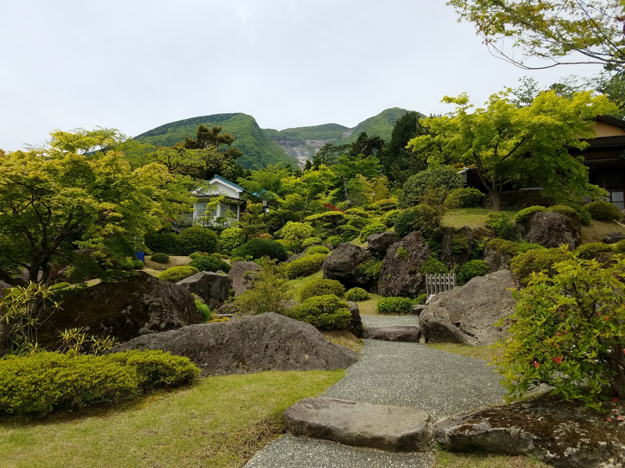
Apart from the moss garden, another section of the museum grounds is a traditionally-Japanese-style landscape garden, called Sekiraku-en (石楽園, lit. 'stone pleasure garden').  It is open only on weekends, holidays, and every day in November, when the maple leaves turn.  I was unaware of this restriction, so I sure lucked out coming on a Saturday when I did.  And it wasn't even all that crowded, either!  The volcanic valley Owakudani can be seen between the mountains in the back.  The sloping, rolling landscape really complements the looming presence of Owakudani; it's easy to imagine both pieces belonging to a single mountain.

There's also a bamboo grove because... this is Japan. I'd be surprised if there wasn't one.

Back at the top of the moss garden is a teahouse, where for ¥700, you can order a cup of green tea and drink it whilst gazing upon the green wonderland below.

The tea was very fine, specifically the powder-based matcha variety, if I'm not mistaken.  It was served with a sweet made from azuki bean paste (小豆餡, azuki-an).  For my first time (knowingly) trying azuki, I thoroughly enjoyed its mellow sweetness.

It reminds me of the time I visited Hokoku-ji in Kamakura.  Not as much bamboo this time around, but far more serene, with nobody else in the room, beyond the server, that I can remember.  After getting our fill of the museum and its scenery, we headed off to another, quite different, museum, which I'll share with you next time on Sekai Ichi!


Hours: Open from 9:30 AM to 4:00 PM; closes at 4:30 PM from April to October.  Admission ends 30 minutes before closing time.  Closed on Thursdays (except in November), 25-31 December, and 4-8 January.  The teahouse is open from 10:00 AM to 3:30 PM.

Costs: ¥900, or ¥700 with an active Hakone Free Pass.  A cup of tea costs ¥700.

Address: 1300 Gora, Hakone-machi, Ashigara Shimo-gun, Kanagawa-ken 〒250-0408

Access: From Hakone-Yumoto, take the Hakone-Tozan Railway to the end of the line, Gora (OH-57, 40 minutes, 4 per hour, ¥410), then take the Hakone-Tozan Cable Car to Koen-kami (OH-59, 3 minutes, 3-4 per hour, ¥170).

The museum is also accessible by bus.  From Hakone-Yumoto (platform 2), take the Hakone-Machi (H) line to Ninotaira-iriguchi ("二の平入口", 17 minutes, every 15-20 minutes, ¥590), then the Kanko-shisetsu Meguri (S) line to Hakone Bijutsukan ("箱根美術館", 10 minutes, every 20-30 minutes, ¥230).  The Hakone Free Pass fully covers both the bus and train routes.

Website(Japanese)